Sunday, June 30, 2013

06-22-13 Together in Port Clinton


Today we saw the Fort Dietrich Snyder Monument signifying were the lookout tower once was to warn of enemy presence during the French and Indian War.

Near PA 183 we stumbled into trail magic. While we drank our sodas and ate our Fruit-by-the-foot, we enjoyed a conversation with a Boy Scout family out for the weekend. With no effort on their part, they talked us into cheese fries at Port Clinton.

After lunch, the Appalachian Trail turned very rocky. We still made decent time, but our feet were tired and sore. We dragged down the final decent into Port Clinton around five o'clock.

The Port Clinton rail yard was a welcome surprise. They had large chunks of anthracite that we enjoyed climbing on.

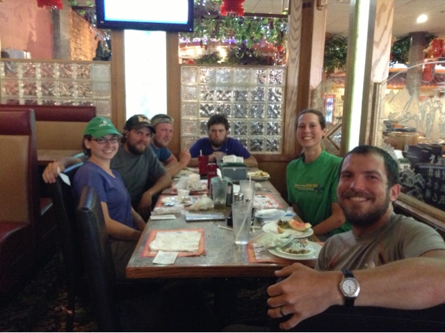
Once in Port Clinton our first stop was cheese fries at the Port Clinton Hotel. After dropping off our gear in the local park, we headed over to Hamburg, Pennsylvania to the Cabela's and Wal-mart.

Back at the park we finished the evening by watching the fireflies under the moonlight.

Saturday, June 29, 2013

06-21-13 Together for the Summer Solstice


The longest day of the year: the summer solstice was today. The Appalachian Trail brought us to an old iron bridge that had been converted from a railroad trestle over the Swatara Creek.

Hiked under Interstate 81 then slipped back into the woods. This section of the trail was overgrown. We wear our pant legs--instead of shorts--covered in Permertrin to protect us better from ticks.

We made it to the 501 Shelter a little after one o'clock and ordered a pizza. Since the shelter is close to Pine Grove, Pennsylvania (and a road for that matter) they're used to delivering. It is a really nice shelter and we relaxed there for several hours.

We continued on three more miles to our campsite. The guidebook listed water but none could be found. Instead, we hiked two more miles to Hertline Campsite. The water source was excellent and we enjoyed dinner down by the pond.

It was fun watching the wildlife in the pond--frogs, fish and even a snake. I definitely didn't have plans to get in the pond after we saw the snake!


Friday, June 28, 2013

06-20-13 Somewhere near the Coal Mines


The Appalachian Trail led us through old coal mining territory. Although none of the settlements exist anymore, we did see large piles of coal next to the trail. Also, the springs put off a yellowish color; needless to say, we avoided those water sources.

In the distance we could hear military planes flying over and artillery fired. We found out from a trail maintainer that an Army Base was nearby.

We got to camp early and enjoyed the evening with friends, Etch-a-Sketch, DNA, Shaman, Hangman, Danno and OB.


Thursday, June 27, 2013

Appalachian Trail 101: Venomous Snakes


For our little buddy back in Alabama:

What are the two types of venomous snakes in Maryland, and what are the two physical characteristics to look for to distinguish it from non-venomous snakes?

We will post the answer next time we have wifi.

06-19-13 Somewhere north of the Susquehanna


Crossed the Susquehanna River today--the dirtiest river in the United States--and disappeared back into the woods.

Once back up on the ridge we had to manage our water due to a 13 mile stretch without water. Unfortunately, we wasted time hiking down the Susquehanna Trail to water we couldn't find. We were able to get water at the shelter half a mile more.

Met Stan preparing to hike southbound at PA 225; we stopped for a break and enjoyed a glass of ice cold water. A couple miles later we ate lunch at view atop Table Rock.

Set up camp for the night on an established campground at Clark's Creek with friends. I missed it, but there was also trail magic close by. B saved me a cold soda, cupcake and some mayonnaise-based pasta salad.

Tuesday, June 25, 2013

06-18-13 Together in Duncannon


Started our twelve mile roll into town early. The guidebook called for six mile stretch of "very rocky" trail. Thankfully, when we got to it, the section wasn't nearly as tough as some rocks we've seen.

Stopped and chatted at Hawk Rock for a moment and took in the view down at Duncannon, Pennsylvania. Arrived in town around 12:30, and stopped at the trail famous "Doyle". Had some lunch and beverage, then laundered our clothes.

Continued our walk through town and up to a campsite near the river; even nearer were the train tracks. Met up with DNA and his dad Stan. We all set up at the campsite and enjoyed a leisurely evening.


Monday, June 24, 2013

06-17-13 Somewhere in the farm fields of Pennsylvania


Recharged at the Appalachian Trail Conservancy Mid-Atlantic Regional Office in the morning before heading north.

The terrain was nice and flat; through farm fields, forest and mulberry trees. At Conodoguinet Creek we made a U-turn. Literally, the trail called for a U-turn, and dipped back into the forest.

We stopped for the night at Darlington Shelter with plenty of room for tents. I got a little miffed when a group of people where heckling my bear bag hanging skills (or lack thereof). I merely found another tree away from them and hung it.

Sunday, June 23, 2013

06-16-13 Together in Boiling Springs, Pennsylvania


Slept in then felt lethargic all day--perhaps a side effect from consuming over 2,000 calories of ice cream? Nah.

The trail led us through a rock maze which was marked with arrows--left, right, up, down. At some point we walk all the way around a boulder. Had it just been left up to us how to get through the maze, we probably would have just gone straight, but it was fun, nonetheless.

Hit the original half way point at Center Point Knob, when the trail first began at Mount Oglethorpe, Georgia. A few rollers to the bottom, the it was corn--err, alfalfa--fields all the way into town.

Boiling Springs, Pennsylvania is nothing short of gorgeous. Situated around a man-made lake built in the 1700s, this peaceful little town is worth a peak.

We bought a few goodies at the grocery store, and spent the evening on the front porch of the Appalachian Trail Conservancy Regional Office which also looks out onto the lake.

We slept on the south end of town in the Hiker's Campground; basically the edge of someone's field, right by the train tracks.

Saturday, June 22, 2013

06-15-13 Halfway Done and Still Together


A monumental day. We hit the halfway point! 1,092.5 miles down, 1,092.5 to go.

To celebrate, we hiked to the Pine Grove Furnace State Park camp store and each bought a half gallon of ice cream. I was worried it was a bad idea and would negatively effect me--if you know what I mean--but we both finished them with ease and I can still stand the sight of ice cream.

While the ice cream settled on our tummies, we walked around the Appalachian Trail a short distance away. While we were there we ran into DNA again!

We camped four miles up with Shaman, Etch-a-sketch and DNA. We're all hoping for a dry night and are all sleeping without our rain flies.


Friday, June 21, 2013

06-13-13 Somewhere where day turned to night


100% chance of thunderstorms. Tore down the tent in a hurry. The nearest shelter was two miles away. We dashed off in a hurry.

The sky turned black. I needed my headlamp; no time. The wind picked up. A branch fell to my left; to my right. I started running. The downpour started. The path turned to a river. Lightning. Thunder.

Please Lord, let me live through this.

Finally, safe in the shelter. We let the worst pass then headed back out.

A new milestone: we crossed the Maryland / Pennsylvania border which is also the Mason-Dixon Line. A little farther up, we hitchhiked into Waynesboro, Pennsylvania.

After a quick resupply and a pizza lunch with our friend, Etch-A-Sketch, we were back on the trail aiming for shelter for the night.

The forecast said another storm system was coming through which either never materialized or missed us. Regardless, it was a peaceful night with fireflies sparkling all around.


06-14-13 Somewhere in Pennsylvania


Hit the trail early and had 12 miles behind us before stopping for lunch. We had a Spam sandwich lunch at the Caledonia State Park.

I feel a little spoiled with all these parks we've passed through. I don't take it for granted though and fully enjoy each amenity. Today I crawled up the rock wall and slid down the twisty slide.

We refilled our water at Quarry Gap Shelter--very nice, complete with potted flowers. So far, we've been impressed with Pennsylvania's shelters.

We pushed on five more miles and set up camp with friend, Etch-A-Sketch. Called it an early night to prepare for the impending "Half Gallon Challenge".

Thursday, June 20, 2013

06-12-13 Together at the Washington Monument


Started the day off at thr Washington Monument State Park--a monument built for George Washington by the citizens of Boonsboro, Maryland. We also said our final good-bye to Big Brother, a section hiker we got to know throughout the Shenandoahs.

Ate lunch atop Annapolis Rock. The clouds were rolling in, but thankfully nothing ever materialized.

We stealth camped off the trail with our buddy Shaman. The forecast called for thunderstorms, but they wouldn't come until the next morning.

Wednesday, June 19, 2013

06-11-13 Somewhere on South Mountain


As much fun as it was to relax, explore the sites and have Mom and Dad spoil us, it was time to get back to the trail.

After my favorite breakfast--eggs over medium mashed together with cheese and hash browns--we were back at old town Harper's Ferry to pick up the trail where we had left it.

Dad couldn't find a parking spot, so just Mom accompanied us over the Potomac River trestle bridge into Maryland. We said our "good-byes" to Mom and turned to leave. But wait. What was that? My Dad, running down the tow path. What a treat! We all continued along the path north. The time inevitably came though, to say our final goodbyes--Thank you Mom and Dad for the wonderful visit!

The Appalachian Trail shared the route with the C & O Tow Path for a couple of miles. Before the railroad, mules used to walk the tow path and pull ferries up the adjacent canal.

We hiked the South Mountain ridge line through Crampton and Fox Gaps, both sites of Civil War battles. Also, we explored the Gathland State Park, which highlighted the role of the newspaper correspondents and artists of the Civil War.

We settled in for the night at Dahlgren Backpack Campground. We're definitely spoiled here--level tent pads, restrooms AND showers.


Tuesday, June 18, 2013

06-10-13 Somewhere near Charles Town, West Virginia


Rain, again. I was thankful not to have to hike in it today. We drove over to Charles Town, West Virginia to look around. Charles Town was founded by George Washington's youngest brother, Charles.

We saw the courthouse where John Brown was brought to and tried and convicted for treason. Also nearby was where he was hung.

We saw Charles Washington's house, "Happy Retreat," surprising, for sale. Looked for a flyer to see an asking price, but none were available.

Had an early dinner at a local restaurant in Harper's Ferry. Scurried back to the campsite during the thunderstorm and enjoyed a quiet evening tucked away from the rain.


Monday, June 17, 2013

06-09-13 Together in Harper's Ferry, West Virginia


Had a lazy morning then proceeded to old town Harper's Ferry. We hung out at the Appalachian Trail Conservancy for awhile and ran into DNA's dad, Stan. What a treat it was to catch up with him!

Harper's Ferry, West Virginia is very historic. Situated between the Potomac River and Shenandoah River it was a strategic point not just during the Civil War but also for the Lewis and Clark Expedition.

We walked around the preserved buildings and saw where John Brown, the abolitionist, was caught during his raid. Peaked inside many other buildings they've preserved for the National Park.

Late in the afternoon, Morning Kid and Bamboo joined us at the campsite and we cooked out for dinner.

Sunday, June 16, 2013

06-08-13 Together with Mom and Dad


Started early on the trail and saw three deer. Today we walked along the ridge line between Virginia and West Virginia and made excellent time.

We reached the sign for the final two miles into Harper's Ferry at 11 a.m. Unfortunately, I was also expecting a "Welcome to West Virginia" or some sort of sign, but none was present. Regardless, I was still excited.

We continued our decent, now fully in West Virginia, and shortly after saw some familiar faces in the woods-- my parents! Definitely NOT dressing the part nor smelling the part, they had hiked in to meet us. After a heartfelt hug, we turned around and hiked the final length into town.

We crossed over the Shenandoah River and into the outskirts of town. A small side trail lead us to the Appalachian Trail Conservancy where we signed in and got our hiker numbers.

We walked back to the Appalachian Trail and hiked to old town Harper's Ferry for a late lunch. With full bellies, we made our way to the Harper's Ferry KOA to reunite with our long-lost cat and settle in for the night. Our hiking buddy, Shaman joined us later in the evening.

Saturday, June 15, 2013

06-07-13 Riding the Roller Coaster Together


Today we hiked the remaining ten miles of the "Roller Coaster. The Roller Coaster is a 13.5 mile stretch of trail with ten ups and downs and a reputation of being difficult.

Fortunately, the Roller Coaster did not pose us much problem. Instead, it was our second day of rain that brought the misery. We'd find out later it was thanks to Tropical Storm Andrea.

Not only did we hit the 1,000 mile marker, but we also reached the Virginia, West Virginia border which we will follow for the next the 15 miles.

To get out of the rain for the night, we stopped at the Blackburn AT Center. The caretakers, Chris and Caroline, were very welcoming and fixed us a spaghetti dinner. Thank you!


Friday, June 14, 2013

06-06-13 A Rainy 17 Somewhere


As soon as the tent went into my pack, I felt a few drops of moisture. The clouds didn't look too ominous and they didn't shed more than a few drops as we left camp.

The miles came and went fairly easy as we traversed a low ridge north. Just before lunchtime we crossed US 50 and on the way up the hill we came across a cooler with sodas and Little Debbie's. Lunch was put on hold as we enjoyed our treats with Bamboo and Morning Kid.

The rain started as we left our break and we didn't take our lunch until we could get out of the rain at Rod Hollow Shelter. The shelter had trash everywhere, an unsettling sight. The "leave no trace" motto means if you pack it in, pack it out.

Just after we left the shelter began the "Virginia Rollercoaster", a 13.5 mile series of PUDs (pointless up and downs). It has a reputation for being tough so we decided to split it up over two days. Maybe jinxing ourselves, but the first 3 miles weren't too bad, even with the rain.

Setting up the tent in the rain was fun but made less painful by the fact that our REI tent can be set up rainfly first. Now we sit in our tent waiting for the rain to stop or tomorrow to come.

Thursday, June 13, 2013

06-05-13 Somewhere North of Front Royal


Zoomed into Front Royal, Virginia early this morning based on two parts excitement, one part hunger.

We got dropped off at the town park and took a small side trail to the back of K-Mart. From there we were able to achieve all our errands--resupply at Martin's Grocery and wifi at Burger King.

Three hours later we were back on the trail. This section of the Appalachian Trail was the western boundary of Confederate Colonel John Mosby base of operations.

We enjoyed the Adarondack chairs at the Jim & Molly Denton Shelter and reunited with Bamboo and Morning Kid!

Five miles later at the Manassas Gap Shelter we setup camp for the night. Struggled with the bear pole--the pole is ridiculously heavy, and actually ended up dropping it. Thankfully it's tethered to the stake so I didn't kill myself.

Had a rousing campfire discussion about ticks; pretty much gave each other the hibbie-jibbies. Ended the day by finding a tick on the inside of the tent, tweezing it, then torching it.


Wednesday, June 12, 2013

06-04-13 Seeing Our First Bear Together


Woke up early and took advantage of the picnic tables and indoor plumbing at Elkwallow.

Today was our last day in the Shenandoahs--no more graded trails, no more waysides or camp stores, no bathrooms. We're back in the deep woods.

On the descent from Compton Peak we saw our first bear! It appeared from uphill out of the brush, crossed the trail, and continued downhill into the woods.

Our day finished at the Tom Floyd Shelter. The shelter is really nice, but the camping is terrible. We walked down a side trail for awhile before we ever reached the tent pad. It is nice and secluded though.

Tuesday, June 11, 2013

06-03-13 Together at Elkwallow


It rained last night, so this morning we awoke to raindrops and spiders all over our rainfly.

Saw the horses at the Skyland stables eating breakfast and later, wonderful views along Stony Man Cliffs.

We stopped for lunch at Byrds Nest #3 Hut and met the southbounder, Momo. She sold us on the Elkwallow Wayside so it became our eminent goal to hike 19 miles today before it closed at 7 p.m.

We hobbled into Elkwallow a little after 5:30 p.m. Each of us had a local bottle of beer--Devils Backbone--and a blackberry milkshake.

Set up our tent--and some spiders--on a gravel access road a short distance from the Elkwallow Wayside.

We've really enjoyed the Shenandoahs and all the amenities. It will be sad to leave as we've gotten a tad spoiled.

Monday, June 10, 2013

06-02-13 Somewhere Near Big Meadows


Betterman was more on his game today and we completed 15 miles in a decent amount of time.

We slept in, broke camp, and used the running water and bathrooms down the hill at the Lewis Mountain Campground.

Hiked up to Hazeltop, the third tallest point in the park (3,812) followed by a nice long descent down into Big Meadows Wayside. Had a lasagna lunch and got a small resupply then were back on the trail.

Found a spring and refilled our water. Set up camp off trail and had instant mashed potatoes for dinner. Drifted off to sleep with the soft sound of rain on our tent.

Sunday, June 9, 2013

06-01-13 Recovering Somewhere


The Betterman felt better, but nowhere near 100%. We got a late start and began with a reasonable pace. About a mile in, the Betterman started suffering.

At one trail junction we took at 15 minute break. Another junction, another 30 minutes.

We eventually crawled into the Lewis Mountain Campground trail junction at 12:30ish. Four and a half hours to complete six miles.

Up at the camp store we camped out for six hours. I had lunch and dinner. B had crackers and more crackers. With the extra time we each took a shower and washed our clothes.

By the evening, B felt decent enough to walk up the hill to the trail and set up camp. Early in the afternoon, Shaman met up with us too--unfortunately he also caught the stomach bug.

Saturday, June 8, 2013

05-31-13 Somewhere in Pukey Town


Yesterday was the type of day that really spoils us. Today was not the same case. First, no waysides within walking distance. Second, the terrain was rolling.

Still made good time by lunch and had the Hightop Shelter to ourselves. The rest of the way was primarily downhill with one little climb just after Swift Run Gap.

At Swift Run Gap we sat down for a short break. It was here that I wasn't feeling that great. After starting, I told K to go ahead as I collected myself. I managed a few minutes more before I was feeling even worse and sat on a nice rock.

At the rock I entered pukey town, population 1. Just after I left the rock, K was waiting for me. It ended up taking us an hour longer to get to camp than it should have.

Our camp was a previous shelter that had been converted to a maintenance shed for the trail maintainers. Even though there was a "no camping" sign, there was a maintainer there who said it was ok for us to set up for the night. Our group were the only ones there so we had the run of the place.

K set up camp and Bamboo fixed me chicken noodle soup as I contemplated my situation. I revisited pukey town a few more times throughout the night which is to say I didn't sleep much--actually, WE didn't sleep much since we are inches apart.

Friday, June 7, 2013

05-30-13 Eating Blackberry Ice Cream Together


Woke up early to beat the heat. That, and we were putting in a longer day to make it to the Loft Mountain Wayside for food.

Stopped for a very early lunch at Blackrock Hut, and a much needed water resupply. We were shocked at how fast we were going--the trail in the Shenandoahs is graded very nicely allowing us for higher mileage days.

We made it to the Wayside ahead of schedule and B stopped in the camp store for a small resupply.

At the Wayside we joined up with Danno, OB, Boo Boo, Bamboo, Morning Kid and Shaman. As recommended by our hiker friends we opted for a hamburger and fries. But the creme de le creme was the blackberry ice cream. The gal behind the counter had her own recipe for no additional charge--two generous scopes followed by vanilla soft serve.

Back on the trail, we tried to camp close to the spring but ended up further north. Enjoyed a small evening snack, hung the bear bag and drifted off to sleep.

Thursday, June 6, 2013

05-29-13 With the Does in the Shenandoahs Somewhere


Trail Angel Yellow Truck took us--Bamboo, Morning Kid, Shaman, B and I back to the trailhead. Today is our first day in the Shenandoahs and we filled out a free backwoods permit for our weeklong visit.

Water and campsites were an issue for us today as there is a span of twelve miles without water and campsites aren't listed as they want us to stay at designated huts.

The mileage was not in our favor and we ended up filling up with a lot of water at mile nine, and camping at mile eleven. Not our most impressive day, but you do what you have to do with what you're given.

We set up camp with friends and enjoyed the evening. As the sun set in the distance a doe walked into our campsite.


Wednesday, June 5, 2013

Somewhere on the Appalachian Trail - What's in B's Bag?


When shopping for gear for the trip; we had to ask ourselves;

"Do we need this?"

"How much does it weigh?"

We did not buy any clothing because we had plenty of running and cycling clothing that was perfect for backpacking. The rest of the gear we made, repurposed, or bought specific for the trip. Since we always camp together, we could share a lot of items. The end goal was for both of us to have our "on the back" weight minus food and water close to 15 pounds. I got to about 18 with winter gear.

I only sent one item home early, my glasses, the rest was exactly what I needed.

Gear I have been impressed with:

REI quarter dome tent - married people need 2 doors yet it is still light.
Columbia omni-dry pants - dry nearly instantly
Marmot Hydrogen sleep bag - kept me warm even when it dropped in the teens even though it is only rated for 30.
Osprey exos backpack - light
Princeton Tech headlamp - only American made lamp and they really fixed me up at trail days
Homemade balaclava - awesome, thank you Mr Hawkins!

Somewhere on the Appalachian Trail - What's in K's Bag?


I started at Amicalola with a pack weight of 23 lbs., and have hovered around that since. I'm fortunate that B and I can share gear (map, stove, tent).

My Favorite Pieces of Gear:

Poncho - It keeps my pack and I dry in the rain. At night, if it's raining I throw it over my pack which sits in the vestibule for extra protection. And last if we stop for a break I like to roll it out and sit/lay on it.

Barclava - It keeps my head, ears and neck warm. If I get too hot, I stow it around my neck so it's ready to pull back on if I cool off. At night, I use it as a pillow case.

Bug Net - I'm a bug magnet, so this way I don't have to put deet on my face.

05-28-13 Together in Waynesboro


Slept in until 7:30 a.m. and hiked five miles to the trailhead. Trail Angel Mystery Lady had just dropped off two other hikers and picked us up on her way back to Waynesboro.

Once in town, she gave us a quick driving tour and dropped us at Ming Garden Buffet in time for lunch. Bamboo and Morning Kid had also just got into town so it was exciting to meet up with them.

We resupplied at Kroger and then hung out with Shaman at the library. We showered and set up our cot for the night at Grace Lutheran Church. Waynesboro was very hiker friendly and we really enjoyed our stay. Thank you!


Sunday, June 2, 2013

05-27-13 Somewhere near Cedar Cliffs


Woke up to a gorgeous sunrise on top of Three Ridges. We made excellent time and hit Cedar Cliffs before noon.

At Cedar Cliffs we met a foursome of hikers--Copperhead and hubby, Totally Bogus and Jenzy--that were a wealth of trail knowledge and had a plethora of stories to share. Funny stories, tragic ones and heartwarming.

 One of the ladies touched me with a story while she was hiking the Appalachian Trail in the 70s. She had left a dollar bill on the windshield of a stranger's car with a note that said "please call this number and let my mom know I'm okay and still having fun." When she talked to her mom next on a pay phone, her mom referenced an unusual call she had received from a hunter saying that her daughter was alright.

 We hiked up Humpback Mountain and the rocks started taking a toll on my feet. I struggled the remaining 7 miles and trudged into the Paul C. Wolfe Shelter, happy to be done for the night.

 We're all set up for the night, and joined by our buddy, Lush. Next to us is a waterfall which peacefully lulls us to sleep.

Saturday, June 1, 2013

05-26-13 On Spy Rock Together


Ate a hardy breakfast, said a heartfelt good-bye to Cyclops then hit the trail.

 Our first sight of the day was Spy Rock. We rock scrambled to the top for a 360-degree view.

 Hiked up the Priest, then down the Priest, then over the Tye River suspension bridge. Luscious caught us and shared homemade brownies with us--delicious! We stopped at Harpers Creek Shelter for a short break.

 Our last climb of the day was Three Ridges Mountain. It snuck up on us and wore us out. We set up camp at the top and enjoyed our taco soup mix for dinner.