Friday, September 27, 2013
Friday, September 13, 2013
09-05-13 Together at the End
Nerves woke me up early. The last weather forecast we had received was 40% chance of showers. I lay in my sleeping bag praying it would hold off at least until we reached the top.
We started our last 5 miles at 6:20 a.m. with all our stuff in tow. Only 4,172 more feet of climbing to do until the end.
The first mile was easy, the second not so bad. A few boulders to hoist ourselves over. More boulders. Before we knew it we were above tree line, in the wind, and the bouldering became more difficult. The rebar sections were intimidating at first, with the wind whipping, but not impossible. A slow mile, but rewarding.
We crested the false summit to "The Tableland" and enjoyed the final 1.5 miles to the summit. As we got close to the top we could see the final summit sign. The moment we had dreamed about for so long was now within reach.
And then we were finished.
We rejoiced in the spectacular view. Throughout our morning climb, the clouds had been clearing out. No rain, only sun. Glorious sun.
As we looked back at the 100-mile wilderness, back at White Cap and beyond, we smiled as we remembered the past 170 days.
From rainstorms to sunshine, arguments to agreements--there we were on the top of the world. Celebrating not only the end of our long journey, but also our anniversary, ready for the next adventure.
Always together, somewhere.

Thursday, September 12, 2013
09-04-13 Somewhere at the base of Katahdin
An easy 10-mile day to the base of Katahdin. After a small "convenience store" breakfast at Abol Bridge Campstore, we set off with our whole troop of friends--Bamboo, Shaman, Morning Kid and Mash.
Into the Baxter State Park Boundary we went for some of the nicest and most graded trail we've had. The two fords of the Lower and Upper Forks of the Nesowadnehunk Stream were tricky however. The water was thigh high, but took our time and successfully crossed without falling in.
Further on, a side trail to Big Niagara Falls beckoned us. We took a short break and explored the falls. On the way back to the trail, we ran into Mash's family, so our train of people became all the more merry.
The final miles into the Katahdin Stream Campground were a blur of bog bridges, banter and giggles.
We relaxed the rest of the day and enjoyed catching up with a few faces we hadn't seen in months--Funnybone, Restless Cowboy, Peanut.
Mash's family generously let us stay with them in their campground and fixed us burgers and s'mores. Thank you! A ranger came by in the evening and gave us our last numbers as thru-hikers. B and I will be the 314th and 315th NOBOs up Katahdin this year.

Wednesday, September 11, 2013
09-03-13 Crossing Abol Bridge Together
Our last day in the 100-mile wilderness. We took our time and enjoyed the trail.
At Rainbow Lake, we stopped for a break. As we were leaving, a sea plane landed in the lake.
Our only climb of the day was up to Rainbow Ledges. The trail and stream were one. We zigged and zagged up, but it was worth it. Our first view of Katahdin.
We stopped at Hurd Brook Lean-To for a long lunch since we have extra food. Spam, tortillas, taco rice and French fried onions. One of our better lunch combination.
The bog bridges signified half a mile to go, and before we knew it we were spit out onto Golden Road--a logging road named this because it cost so much to build.
We crossed Abol Bridge over the Penobscot River and saw another magnificent view of Katahdin. A thunderstorm was approaching which made the scene more enchanting.
We waited out the storm in the Abol Bridge Campstore. As the rain let up we ventured across the street to the Abol Pines Campground for the night.

Tuesday, September 10, 2013
09-02-13 Somewhere near Rainbow Brook
Woke up early and were packed up and moving before the rain. The trail today was fast and we completed 12 miles by 12 o'clock to the Cooper Brook Falls Lean-To.
The shelter was timed perfectly. We were able to stop out of the rain and have lunch. It was hard restarting though; venturing back out in the pouring rain.
The trail was very pretty. It meandered through the pine trees next to several lakes and rivers. Several points on the trail offered views to Katahdin. Unfortunately, the mist billowed up, and we were unable to see her yet again. It makes the mountain all the more mysterious.
We pushed hard the last two miles with the hope of sleeping out of the rain. We ended the day with 20 miles--our second highest mileage day of the trip--and snatched up the last two spots in the Rainbow Brook Lean-To.
In the shelter, we were joined by Bamboo, Morning Kid, Mash and Keystone. We enjoyed mash potatoes with bacon bits and French fried onions, tucked away from the rain.

Monday, September 9, 2013
09-01-13 Somewhere near Jo-Mary Lake
The terrain flattened out nicely as we made excellent mileage and time today. We had a small 400 foot climb over Little Boardman Mountain while the rest of the day was a gradual walk down.
We stopped for a snack at Crawford Pond and lunch at Jo-Mary Road. While we ate the crew assembled back together. B's stomach ailment was a hot topic and resulted in a cell phone call to Mash's dad and uncle (both doctors). Nothing conclusive was decided. Only B was having problems and the 100-mile wilderness is a horrible place to have problems.
Regardless we kept moving north and settled in for the night on a beach at Jo-Mary Lake. Watched the sunset then turned in for an early night.

Sunday, September 8, 2013
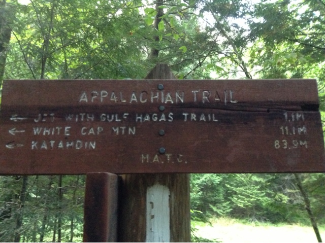
08-31-13 Up on White Cap Together
Today the terrain was amazing. Enjoyable even. We climbed Gulf Hagas, West, Hay and White Cap Mountains.
Up on White Cap we were unable to see out, but a little farther down, we were under the clouds and got a view. Still not clear enough to see Katahdin. We will just have to anxiously await her entrance.
We started and ended the day with rain. Thankfully not when we were hiking, nor when we were setting up or tearing down the tent. This rain I can handle.
Poor B has come down with some unknown stomach ailment. He has had to stop every few hours to unload his frustrations. Luckily, Check-6, a section hiker, had Imodium for B to take. He's hoping after the generous dosage he took, he'll be plugged up for the remainder of the 100-mile wilderness.
We set up camp with our friends at East Branch Lean-To. Dined on teriyaki rice with chicken and called it an early night.

Saturday, September 7, 2013
08-30-13 Somewhere near the Chairbacks
Today marked our second day in the 100-wilderness, and it was hard. B and I have both had our share of falls. B has a series of ugly knots on his shin; I, a couple of impressive bruises on my hip.
Every mile we had to work for. Occasionally we were rewarded with nice trail, a majestic view or a sliver of sun.
Today the trail took us over Barren, Fourth, Third, Columbus and Chairback Mountains.
The descent off Chairback was long and tedious. Our spirits were declining as quickly as the terrain. At Katahdin Ironworks Road, a gravel road, was a case of soda. The trail magic perked our spirits and made the last leg of our day's trek easier.
We forded West Branch Pleasant River and decided to camp to the north of it, even though it was a designated no-camping area with three other hikers.
A ridge runner walked up to the river to fill his jug as we sat there, drying our feet, and asked us where we were camping. He told us we couldn't camp there, but a developed campsite was nearby that wasn't in our guides.
We thanked him for the information and headed to the site for the night. Our tent was next to the river, so we listened to the subtle sound of rushing water as we fell asleep.
Friday, September 6, 2013
08-29-13 100 Miles From Katahdin Somewhere
Today's theme was water. Rain. Ponds. Waterfalls. Rivers.
It rained through the night and was still sprinkling when Rebecca from Lakeshore Inn dropped us back at the trailhead. Thankfully, the rain was short lived, and the sun poked its head out periodically throughout the day.
Today we entered the 100-mile wilderness. A sign at the entrance warned us of the rugged and remote dangers we were entering into. We plowed ahead, eager. This marks the beginning of the end.
The trail was a blur of puddles, ponds, puddles that looked like ponds, streams, rivers, streams that looked like rivers, mud, bogs, and mud that looked like, well, mud.
Little Wilson Falls was a spectacular waterfall with sheets of rock making it look very geometric and artistic.
We popped off our shoes to ford Big Wilson Stream and again at Long Pond Stream. As our feet dried off at Long Pond we quickly celebrated being 100 miles from Katahdin.
After a long and strenuous day--the terrain wasn't hard, I just think we're fatigued--we crawled into Long Pond Stream Lean-To for the night. We quickly set up the tent, fixed dinner and filtered water so we could call it an early night.

Thursday, September 5, 2013
08-28-13 Together in Monson, Maine
An easy day. Only a six-mile nero into Monson, Maine. We were in town by 9:30 a.m.
Our first order of business: my mom's mail drop at the post office. Monson is a small town; the only place to buy "groceries" is a small gas station. We knew this ahead of time, and my mom was delighted to help us out with six days of trail food.
Rice sides. Spam. Snickers. A well-rounded diet. Thanks Mom!
We had a leisurely lunch with Mash, Morning Kid and Grey Cloud at "Thymes and Seasons". The restaurant is in a community center; they cook the food in the industrial kitchen somewhere else in the building, then wheel it to the other side to serve it. Not the fastest nor most efficient setup I've ever seen (from ordering to paying took 2 hours) the experience was one-of-a-kind.
We stayed at Lakeshore Inn in the attic. The inn was a lot of fun; downstairs was a restaurant and bar; out back the lake with water toys. It rained the latter half of the day, so we reluctantly hung out in the bar. From 4 to 6 was "Happy Hour," half price drinks.
The crew--Bamboo, Morning Kid, Shaman, Mash, Grey Cloud, B and I--set up "camp" amongst two tables.
It being a small town (and a Wednesday), the bar closes when there aren't any more patrons to serve. We "closed" the bar down at 8:00 p.m., when we all left to go to bed.

Tuesday, September 3, 2013
08-27-13 Fording the Piscataquis Together
Started the day with a pleasant climb up Moxie Bald Mountain. Although once to the top there was no view because of the fog, we could tell that the sun was anxious to shine through.
The descent was pleasant as well. We did have to be doubly careful because some of the rock facades were slick which added an extra level of challenge.
We stopped for a quick break at Moxie Bald Mountain Lean-To. The lake in front was so inviting, it was hard to leave.
We did though and continued through a deliciously flat section. The trail led to Piscataquis River. B had no problems rock-hopping across, but I was not as lucky. With two wet shoes and four wet socks, we continued on our way.
Although the trail profile called for flat, we were up and down and up and down. Finally it tamed down, and we made good time to Piscataquis River crossing (again). I was taking any chance this time. With bare feet and sandals I forded the stream while B rock-hopped across.
We continued a few more miles and set up camp in a nondescript location amongst the pines; pine needles make excellent sleeping pads.
Enjoyed dinner and Rob and Jessica's chocolate chip cookies. With full bellies we called it an early night.

Monday, September 2, 2013
08-26-13 Together with Barbie's Leg
The sound of light rain woke us up early. We decided to sleep-in and broke camp when the drizzle lightened.
A shuttle took us to the Caratunk, Maine post office where a package from Rob and Jessica awaited us. Inside was all sorts of goodies: chocolate chip cookies, trail mix, chocolate peanut butter. Also include was a small trinket; a Barbie doll leg with "Good luck on your last leg written." We both got a long laugh out of it. Thanks Rob and Jessica for your generosity and your humor!
Back on the trail we climbed Pleasant Pond Mountain with Morning Kid and Mash. The climb kind of snuck up on us and the four mile descent was long and drawn out. The rocks were slick from the morning rain, but luckily no major falls, just a few "dance moves" as Mash refers to our slippery shuffles.
Once to the bottom we knew it was just a three mile push to Bald Mountain Brook Lean-To. Rock hopped over Baker Stream then an easy grade to the shelter.
Tonight we are camped with the usual suspects, along with a spunky retired English teacher, Slow and Steady.

Sunday, September 1, 2013
08-25-13 Lost in the dark somewhere
B here, finally got to write a day's entry after a long time off.
The shelter was a good decision allowing us to get an early start. The trail was easy; after breaking at East Carry Pond Beach midmorning, we still clocked 10 miles to the Pierce Pond Lean-to by lunchtime.
We relaxed pond-side, watching a loon fish on the lake fit for a postcard. There was no need to rush; the ferry didn't resume again until 2:00 p.m. at the Kennebac River.
The ferry has operated since the beginning of the AT and is the only ferry service on the trail. The Kennebac crossing is downstream of a hydroelectric dam; the water releases are unpredictable and cause the water to rise over 15 inches within a minute. While we were there, we witnessed how fast the water moves after a release. Many hikers have risked fording and have gotten into serious trouble on this otherwise tame looking river.
Our canoe ferry made it safely across and we ventured to the Northern Outdoors Resort in Caratunk, Maine for tasty burgers and micro brews as an afternoon snack.
K stayed at the lodge while I set up the tent across the street in the campground. I returned for happy hour and air conditioning.
It was getting late, so K left for the tent while I stayed at the lodge. After what I thought were excellent directions to the tent, she was on her way. What neither of realized, though, was how dark it would be. Not only was the campground poorly signed, but it was pitch dark too.
When I got back to the tent, I noticed K wasn't anywhere around. Morning Kid checked the lady's restroom and confirmed K wasn't there.
At this point I realized I was now on the hunt for a lost and highly-likely angry K somewhere. After a few rounds of the campground, I checked the lodge. Still no K.
It had been an hour since the last K sighting, and our friends were ready to help. Our plan included I and 5 other thru-hikers combing the campsite. Another 30 minutes. Still no K.
A vacationer drove me around the major roads as our friends began round two. My driver also happened to be a police officer so while we calmly looked for her, I got to answer all the standard police questions.
"Did you two get into a fight?"
"Not since we got separate trail mixes"
More cop questions: "Could she have run away?" and "Does she have any medical condition?"
The driver dropped me at the lodge; I was now really worried. Our next plan was to search the empty camp cabins. As I was running to my search area, MASH informed me that he had found K in a cabin tent farther down.
After she had walked down to the campground and some indeterminate distance, she realized that she didn't know where or how far she was going in the dark. She then stopped at a cabin tent and waited for me to come by.
Thankfully the story ended well, and is now just another side-adventure of our Appalachian Trail journey.

Subscribe to:
Posts (Atom)